
Shortest post ever 🙂 Windstorm scenario has chilled out thankfully, and we are left with just breezy winds today. Gusts should stay below 40mph. No big deal, but was a close call, and the most weather model disagreement I have probably ever seen going down to the last minute. Good to always be prepared anyway. Merry Christmas!!
Wind impacts for Christmas Eve
Confidence is remarkably low for being less than 24 hours from this storm, but confidence is growing in a very impactful wind scenario. Please read through all of these important headlines concerning the potential wind storm for Wednesday.
1.) I’m forecasting wind gusts of 45 to 55mph here in the Willamette Valley. This is plenty strong enough to cause power outages and bring down more trees. This will be a very short hitting, but powerful storm. Look at this forecasting chart for Salem. I have arrows pointing to the day and time columns, the surface wind gusts, and the precip column.
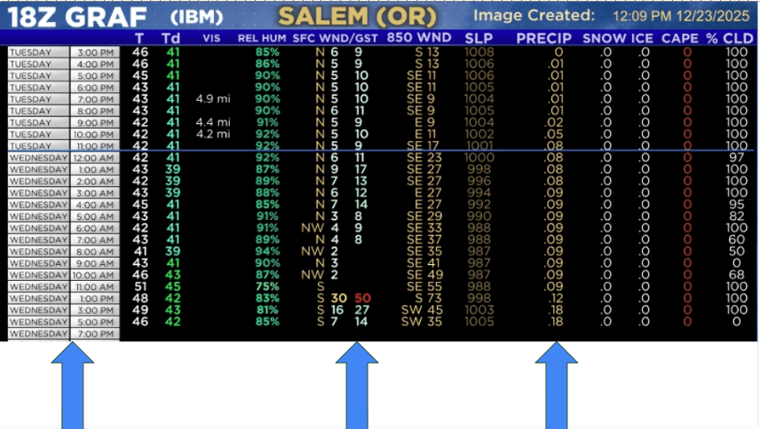
This storm is not a rain maker at all, and it will feel like it came out of nowhere, and will be over within a few hours, but the damage will already be done. This model actually had even higher wind gusts in its previous run, and has been bouncing around some. Right now, 45 to 55mph for the Salem area is a good bet with higher gusts still on the table.
2.) Plan on the possibility of doing Christmas Eve and maybe Christmas without power. This sucks I know, but it’s what I see as a real possibility.
3.) Plan on some of the coastal highways and highways going over the Cascades closing tomorrow during/after the storm due to downed trees.
4.) Copied from my last update, but still very relevant: Understand that highways may close Wednesday and stay closed through at least part of Christmas day due to downed trees or power lines. Again, please consider traveling sooner rather than later if you have the option to avoid closed highways. If you end up leaving early and nothing happens, I doubt you will regret it, but if you miss celebrating Christmas with family because every highway crossing the Cascades is closed, then it’s a much sadder story.
5.) Please prepare for power outages Christmas Eve and possibly lasting longer. Please plan on some road and highway closures Christmas Eve and possibly lasting longer.
Adding to this, I don’t think you will be sad if you plan and are prepared for power outages and they don’t happen, but you will be frustrated if you’re not prepared and they do take place.
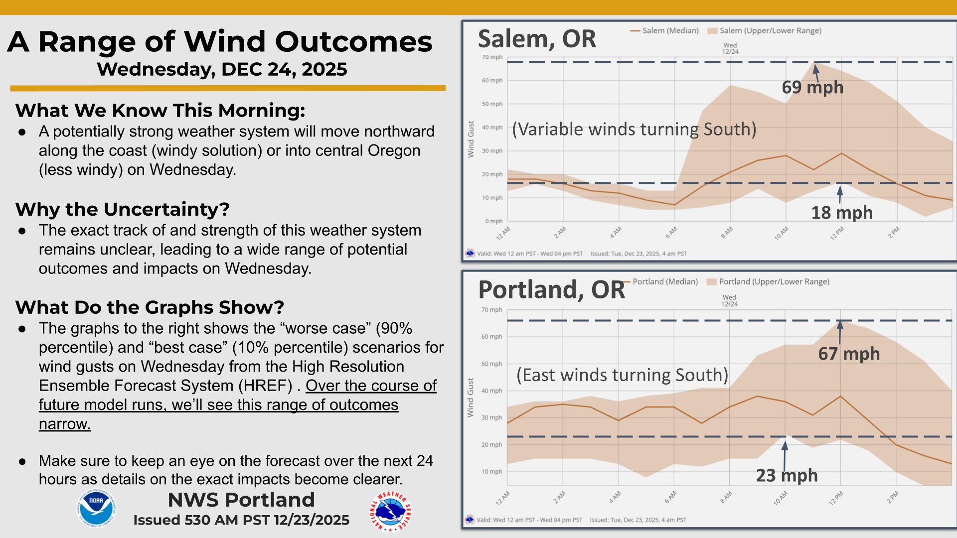
Like always, feel free to search elsewhere for additional details, but you may struggle to find more. Look at what the National Weather Service is putting out today. Talk about a wide range of possibilities…
6.) Unsure if I will have a final update before the storm. I suppose the only reason to have another would be if a more severe outcome is looking more likely; otherwise, please be ready, be safe, and hopefully we get through this with minimal damage.
Important weather update
The update I promised, and it’s one of the tougher updates I’ve ever done. Tough because so many people have plans this week for Christmas, and tough because I’m still not sure what will happen, and that can feel frustrating. The rest of today and Tuesday will feature more of the same: breezy at times, sunbreaks, showers. The steadiest rain will occur this evening around 4 to 8pm tonight. Now for the tough part.
In my last update, I mentioned the potential for strong winds in the Cascades and over in central Oregon. It’s looking more likely that those strong winds could also move through the Willamette Valley. Please carefully read through these important highlights:
Highlights
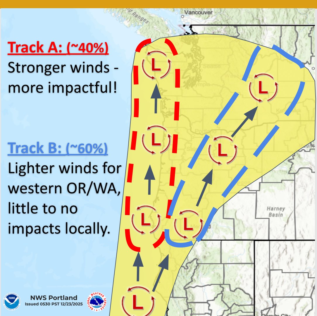
1.) A very small low pressure system is expected to move from south to north Wednesday morning. It’s small, but locations near the path will experience strong and damaging wind gusts. That part seems certain. The path the storm takes is still very uncertain.
2.) Understand that highways may close Wednesday and stay closed through at least part of Christmas day due to downed trees or power lines. Again, please consider traveling sooner rather than later if you have the option to avoid closed highways. If you end up leaving early and nothing happens, I doubt you will regret it, but if you miss celebrating Christmas with family because every highway crossing the Cascades is closed, then it’s a much sadder story.
3.) Because it’s Christmas this week, and due to the potential for disruptive weather, I will provide an additional update as soon as things become more clear.
4.) Be prepared for power outages on Wednesday that could last through the week.
5.) This will be a quick hitting storm (if it does hit us). Calm weather returns Wednesday evening. Thursday through next Tuesday (the 30th) look extremely calm. We just have to hope we either dodge this storm, or make it through it, and then it will be smooth sailing.
6.) Lastly, keep in mind nothing is final yet. More changes to come.
Below are three images showing top wind gust speeds for Wednesday. See why this is a tough call? Some of these outcomes would be devastating, some would limit the strong winds to the mountain passes and central Oregon still, and some would be no big deal whatsoever.


Rest of week details
Thursday (Christmas Day): Wet with light rain much of the day. High of 48°.
Friday and Saturday: Scattered showers with sunbreaks. Highs in the upper 40s.
Sun – Tue: Foggy, maybe some afternoon sunbreaks. Dry. Highs in the lower 40s, and lows near freezing.
The Cascades
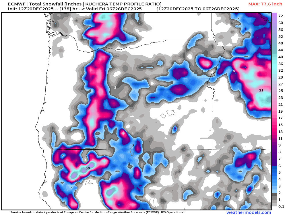
Christmas will probably be the snowiest day in the passes, but snow showers will persist through Saturday. Sunny and beautiful Sunday through next Tuesday! Unfortunately, I only see around a foot of new snow this week which is probably not enough to open new terrain.
Stay safe and keep an eye out for another update!
Christmas forecast
A really nice day today, in fact, the second great day in a row here! Water levels are going down now (even on the slower responding rivers), but standing water may persist in many of these low laying areas, rural locations, and some of our local parks. There is just too much water and the ground is not able to soak it all up at this point. Be sure to check ODOT, and park websites to check for road closures, State Park closures, and well, closures in general. There are a lot of roads, highways, and parks still closed for the foreseeable future, and it would be prudent to check before making plans.
Link for ODOT travel conditions here: https://www.tripcheck.com/
Use this link to check the status of State Parks. Just type in the name of the park you wish to inquire about and (hopefully) up to date info will appear: Oregon State Parks
I’m watching one storm for Christmas Eve that could cause some gusty winds, especially up in the mountains and over in central Oregon. Besides that storm, the weather looks pretty calm through Sunday the 28th. This gives us a nice window to travel and enjoy Christmas without weather impacting us too much.
Extended forecast

Details
Now through Tuesday is pretty straight forward. There is a chance for a shower at almost any given time over the course of these four days, but there will also be plenty of dry breaks in between (like we are seeing right now). The wettest timeframes look to be late Sunday afternoon, and Monday.
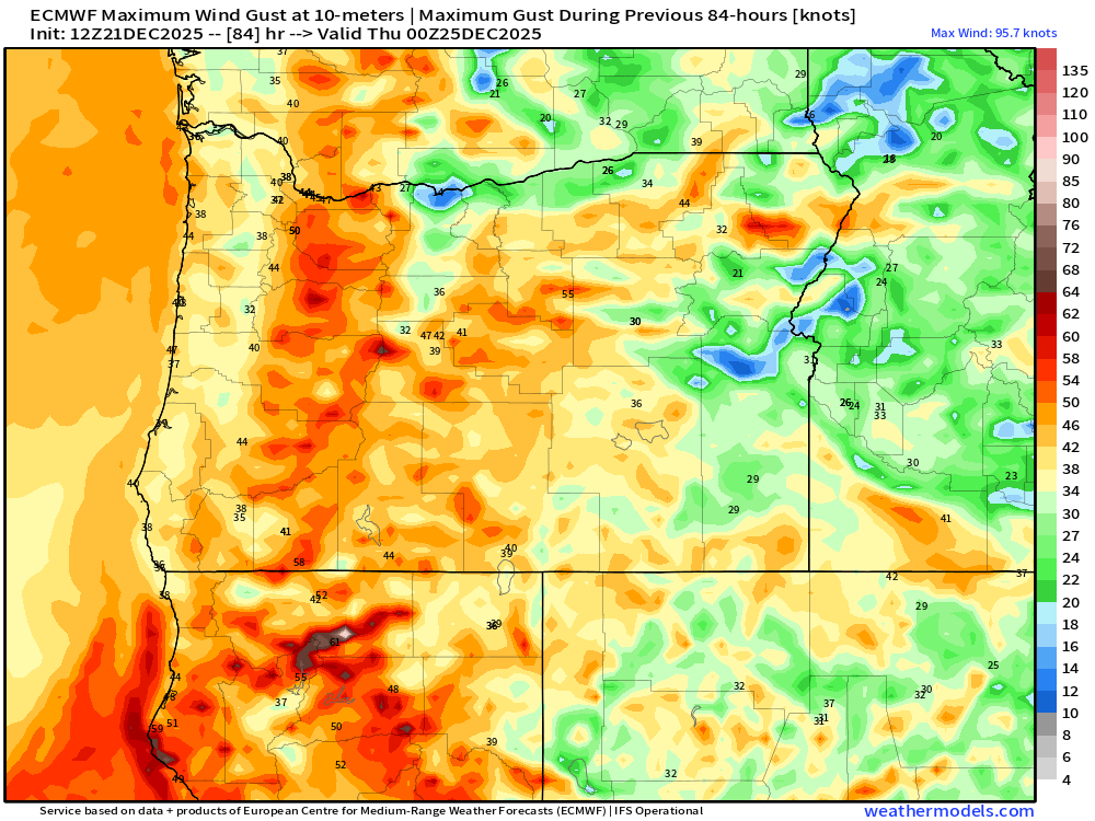
Wet and breezy on Wednesday, but nothing too strong in our area. The strongest winds will take place in the Cascades, central Oregon, Wallowa mountains, and the Siskiyou Pass heading down towards Shasta. Because Christmas Eve is such a big travel day, I think it’s worth keeping an eye on this forecast. I did a little sketch to highlight these areas for you all. I’m clearly not an artist lol. The numbers you see on here are estimated max wind gusts in knots.
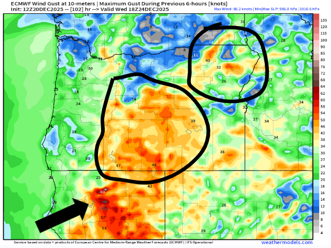
The potential exists for some really gusty winds in the highlighted areas early Wednesday morning/early afternoon, and if you plan to travel to or through any of these areas on during this time, then keep a close eye on the forecast. I will have another update Monday morning highlighting any changes to this forecast.
Once we get past the wind event Wednesday, travel conditions look pretty great through Sunday the 28th.
The Cascades
Mountain snow slowly accumulates in the coming days with a few inches here, and a few inches there adding up to a little over a foot of new snow through Christmas Day. Not great, but it’s a start.
The final days of 2025 look to be on the cooler side with additional storms bringing valley rain and mountain snow. If resorts are not able to open by Christmas or the day after, then I think they will be able to by New Year’s Eve as we stay on the cooler side of the jet stream. Let’s hope that stays the case!
Have a fantastic weekend and enjoy the beautiful weather as it presents itself! 🙂
Flooding concerns
A very short post tonight. Flooding is widespread and as long as it keeps raining, it will only get worse, especially here in town with the small urban creeks. I see Battle Creek in south Salem is now flooding and will rise more over the next few hours. I imagine Pringle Creek and Mill creek will also continue to rise more through the night before leveling out. Heavy rain continues here in Salem for a few more hours before changing over to showers around midnight.
Tomorrow will feature scattered showers and sunbreaks, but the damage will have been done. Slower responding rivers like the Willamette, Pudding, Luckiamute, and Marys River will all continue to rise throughout the day on Friday as the mountain ranges and smaller streams drain into them. Rainfall records are being set in many locations. Salem is well over two inches for the day, Tillamook is well over 4 inches, and the Albany area is approaching 4 inches of rain just for today!
Lots of flooding on streets and in parking lots tonight. The rest of the week and weekend looks showery, but normal. No insane rainfall totals for the near future once we make it through this storm.
Okay, stay safe out there.
Briefly catching our breath
For many of us, today’s regular schedule was disrupted due to the aftermath of last night’s windstorm. Lots of delayed and even closed schools, PGE and Salem Electric together reported thousands power outages very early this morning, and plenty of blown over fences, trees, and debris in the roadways. I had no trouble finding evidence of the storm while out and about today. Unfortunately, the weather is going to hit us hard again tomorrow.
Details
Thursday
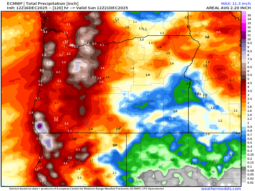
The forecast really has not changed at all. Expect steady, heavy rain to fall the majority of the day. Most valley locations from Eugene through Vancouver Washington will pick up close to two inches of rain, and some valley locations could get over three inches of rain with just this one storm. Yes, this will be a top tier rainstorm for some of us. It all depends on where the very heaviest rain tracks; regardless, everyone gets a major soaking which will bring creeks, streams, and rivers back up. Rule of thumb, if you had high water with last week’s rainstorm, then expect just as high or higher water levels with this incoming storm. The map below depicts the expected rainfall totals through Friday morning.
Foothill locations and the mountains should get between 4 and 7 inches of rain. Some of that rain will melt the fresh snow that fell today adding to the flooding concerns.
There is a Flood Watch posted which covers all of western Oregon, and instead of naming all the rivers that could flood, I’ll just leave you with this graphic. If you live in the green highlighted area, and you live in a historically flood prone area, then you should pay attention and prepare for high water levels.

You can also find out river level forecasts from this link here: River level forecasts. Just keep in mind that these river forecasts change (up and down) frequently, and are meant to give you a general idea. The South Yamhill, Pudding, and Luckiamute rivers are three specific rivers expected to approach moderate flood stage levels.
Stronger wind gusts make a return appearance on Thursday as well. Widespread gusts of 35 to 45mph for the Willamette Valley, and gusts up to 55mph in the mountains and along the coast. A little weaker than the winds we saw last night, but these wind gusts could go on for a longer period of time. Add in the heavy rain, saturated soils, and we will certainly see additional power outages and downed trees. Winds peak in the very middle of the day (11AM to 3PM) before subsiding. Heavy rain will continue through Thursday night even after the winds die down.
Friday – Tuesday
Regular Oregon weather is expected. Showers each day, sunbreaks at times, a few downpours here and there, periods of rain (especially Sunday and Monday evenings), and breezy winds from time to time, but nothing too wild. Highs in the mid to upper 40s. Snow is going to really start to pile up in the Cascades too. Snow totals from Friday through next Tuesday will range between two and three feet of new snow. Finally some good snowpack, and perhaps, enough snow for ski resorts to open up for the season.
Here’s a link to the Discord page if you wish to pop on there. The plan is to share weather related photos on there as well as short updates to the forecast: I also found out that you can join Discord on your web browser without having the app. Link is here if interested: Bryan Weather Alerts on Discord
Hoping you all can relax this evening before the weather beats us up again. Stay safe out there!
Wild weather
Sometimes I think to myself “Do I overuse this phrase?” My answer was “maybe,” and maybe I need a specific criteria for using the word “wild” in forecast titles. Regardless, I think the upcoming weather qualifies as “wild” lol. Highlights are here with details further below.
- Expect some very heavy rain and strong gusty winds tonight. Wind gusts up to 50mph.
- Scattered power outages possible anywhere in western Oregon tonight.
- Slight chance for thunderstorms tonight through mid day Wednesday.
- Strong winds return on Thursday.
- Very heavy rain all day Thursday through Friday morning – 2 to 4 inches.
- Flooding Thursday and Friday – on a slightly larger scale than we saw last week.
Details
Tonight
Wind gusts will range between 45 to 50mph. This will match or exceed the strongest gusts we have had so far this season. Wind gusts are never uniform across the whole valley, but most of us can expect something close to that range. This is a very dynamic cold front moving through, and the warm moist airmass currently in place will help fuel these strong winds. As the front passes over the valley, temperatures drop 12 to 15 degrees just within a couple of hours. Bursts of very heavy rain are also expected tonight. This storm will mostly take place while we are sleeping (9PM to 4AM, but don’t be surprised if the weather wakes you up tonight.
Power outages and downed trees usually over perform whenever we have saturated soils. Be prepared for scattered power outages tonight and lasting through at least the morning hours.
Thursday’s rainstorm
Here in Oregon, this will be more impactful than last week’s rainstorm. Confidence is growing that steady rain will begin early Thursday morning, and lasts through the first part of Friday before switching over to a few afternoon showers. Rainfall rates look impressive. This map shows rainfall totals between now and Sunday morning.
Rain totals like these will cause at least some flooding. I’ve attached water level forecasts of four area rivers, and in all four cases you can see river levels are expected to go higher than what we saw last week. This tells me flooding could impact a higher percentage of us by the end of the week. Click on each image for a closer look.

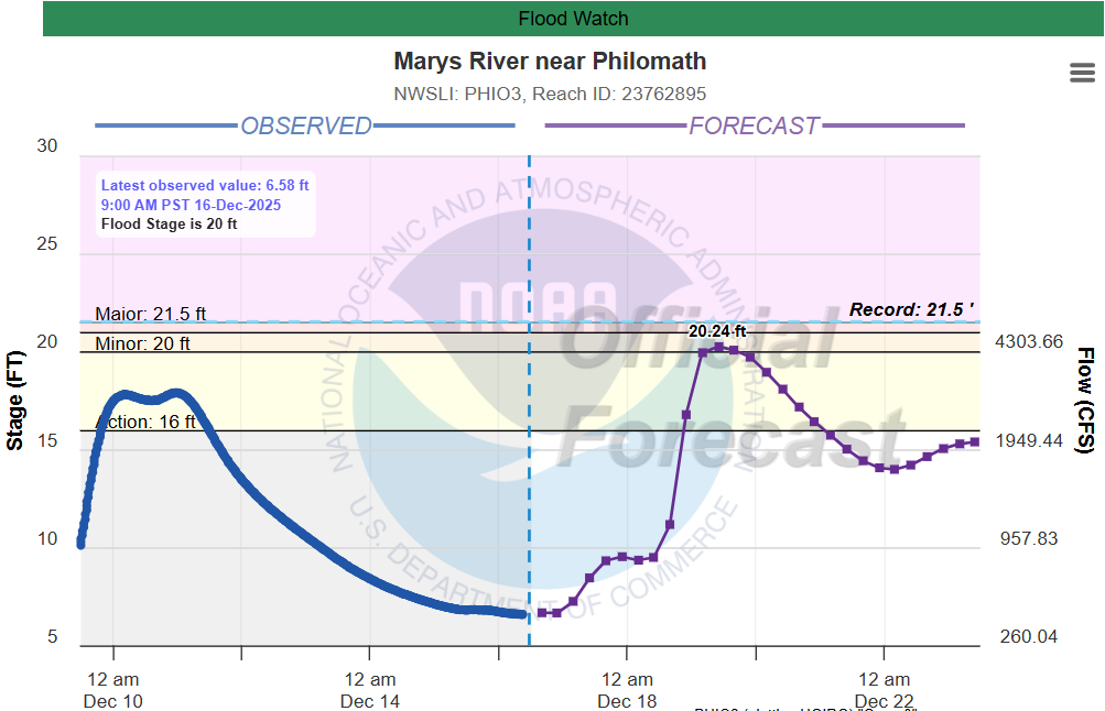
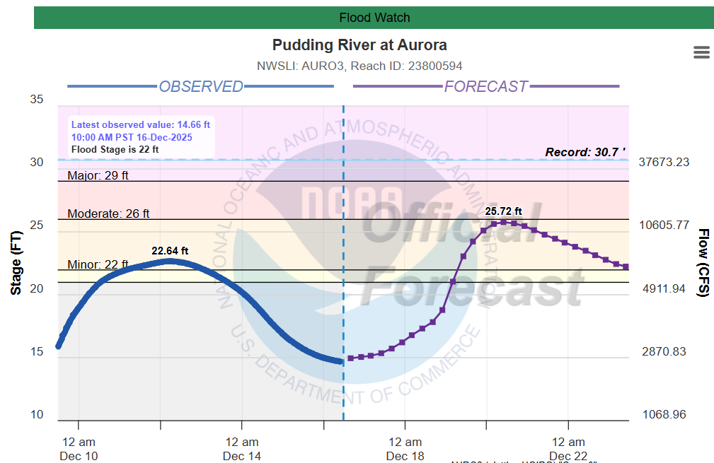

The Willamette in particular is expected to be significantly higher than it was last week. Something to watch. Winds also pick back up in intensity on Thursday giving us another threat for additional scattered power outages.
Friday afternoon – Monday
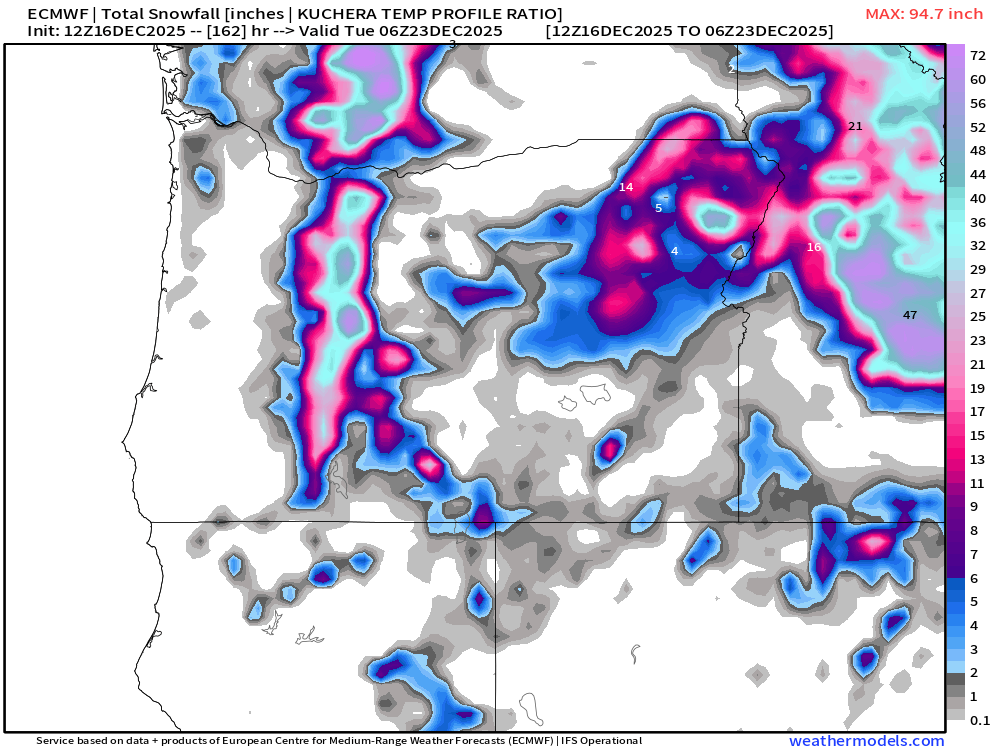
This will be a cooler stretch of days with highs here in the valley around the upper 40s. As of right now, no big storms during this timeframe, but a cool, onshore flow will keep showers going in the lowlands, and snow up in the mountains. In fact, it should be a pretty good mountain snow pattern. Totals through Monday night shows the Oregon Cascades picking up a few feet of snow. Maybe there will be skiing in time for Christmas after all. Chains or traction tires will either be recommended or required going through the passes Fri – Mon.
Bryan Weather Alerts on Discord
Take care, and stay safe out there!
